BGSU Shuttle Services
Prototyping, Wayfinding System Design, Research
As part of a campus-focused environmental initiative, the BGSU Shuttle Service plays a key role in helping students travel efficiently while reducing carbon emissions. Although digital tools like the Transloc app assist in shuttle tracking, the physical wayfinding system needed improvements to match the service's eco-conscious goals. This proposal aimed to enhance clarity, visibility, and accessibility through simplified shuttle maps, updated signage at shuttle stops, and in-vehicle stop trackers, making the shuttle experience smoother for riders.
Strategy
This redesign was informed heavily by direct observation and firsthand experience. I spent several days tracking how students navigated the shuttle system, where they naturally paused, looked for signage, and became confused. I also spoke with frequent shuttle users, to better understand recurring challenges they faced with public transportation. Their insights revealed key problem areas such as unclear stop labeling, lack of directional cues, and a lack of a physical route map. These findings drove a simplified, student-centered design system aimed at clarity, legibility, and better real-time navigation.
Skills
• Prototyping
• Research Based Design
• Organization and clarity
• Adobe Creative Cloud
• Project Management
• Wayfinding System Design
• Collaboration with others
Research Presentation
Wayfinding, Presentation Design
This presentation outlines the research and strategic design decisions that informed the shuttle system redesign. From simplifying the route map to designing clearly visible signage and tracker systems, each design decision was tied directly to feedback from the campus community. The presentation provides a deeper dive into how visual hierarchy, color coding, and physical scale were used to improve clarity and accessibility across the BGSU shuttle experience.
User Circulation Maps
& Wayfinding Strategy
Wayfinding, Research
This section highlights four detailed maps that break down user movement and visual focus within the BGSU shuttle system. The first two maps focuses on circulation inside the Centrex shuttle station, showcasing where students naturally move, pause, and seek information. The last two maps targets behavior inside the shuttles themselves, tracking how students orient themselves when inside the shuttle. These maps were key to guiding placement and scale for signage, ensuring that every visual element aligned with user behavior to create the best wayfinding experience.


Wayfinding Elements
Wayfinding, Prototyping
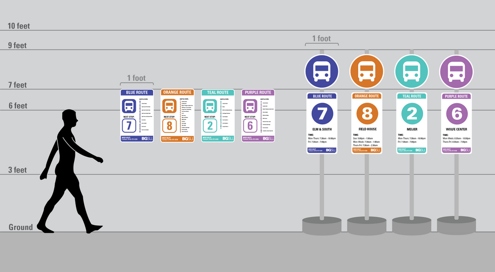
Each element is visualized at full scale within its intended location, whether in the Centrex station or onboard the shuttle, demonstrating how the system would feel in everyday use. A size comparison graphic illustrates how signage interacts with human scale, while a fully constructed, to-scale prototype of the in-shuttle tracker offers a look at the system’s modular functionality and communication goals.


